| Field
Service |
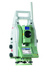
 3 Leica / Zeiss precision Tacheometers TS30 3 Leica / Zeiss precision Tacheometers TS30
|
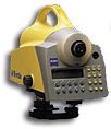
2 digital Leica/Zeiss
Levelling Instruments
4 GNS Station
|
2 permanent Continuous
Monitoring Systems
Also available: a measuring sensor for recording temperatures
and determining ground water levels
For control, data collection, data evaluation and data
transfer we use the Observer Professional software system (Geomos and CBP)
in conjunction with a program that we ourselves have
developed for data analysis, plausibility checks and
documenting measurement results.
We use the GEOTEC PANDA V2.50 program system for computing
forecasts and simulations. |
|
Guidance systems manufactured by the companies VMT / Schwarzer
Laser Tracker Industrial Measurement System Manufactured by Leica
Our company can also supply a wide range of accessories
All these devices
use state-of-the-art technology. They are regularly examined and waited. |
Office Work |
Graphic Workstations
|
Measurement Software
| Correction
software: |
PANDA, Spazial Analyser,CAPLAN |
|
| Calculating
program: |
Survey, CAPLAN |
|
| Digital
Terrain Model: |
Auto CAD, CIVIL 3D |
|
| Levelling
evaluation software: |
Nigra |
|
| Diverse
applications: |
own developed Applications (CPV) |
|
| |
|
|
|
|